Almost three years ago I wrote about the proposed land swap between the BLM and the Agua Caliente Band of Cahuilla Indians (ACBCI), and why it was a bad deal for the public.
A couple days ago I received an email from the BLM with links to three documents. Having spent considerable time reading all of this, I think it is a good deal for the public and the tribe.
We the people… made a difference, again!
And as in another post, We the people… made a difference at Anza Borrego, we the people made a difference regarding the BLM and ACBCI land exchange. There is still going to be a land swap, but this one makes sense for the public, the ACBCI, and the BLM. If you are a frequent reader of this blog, you know I am critical of most government agencies and the BLM has been the focus of much wrath on my part. That hasn’t changed, but in this case I will admit the BLM has done the right thing (at least it seems so, as far as I can discern) – at the urging of many citizens who challenged their initial proposal a few years ago.
So what is the result? I’ll get to that, but first we need to understand the tribal land holdings in Palm Springs, it is quite unique and beneficial to the tribe.
The Golden Checkerboard
The Agua Caliente Indians number a little over 400 members, and the holdings of common tribal lands and individual member comprise 50% of the land in all of Palm Springs, plus there are substantial holdings in the adjoining cities of Cathedral City and Rancho Mirage. If you look at the Palm Springs area, it is divided into sections of land (a section is 640 acres) and like the checkerboard above, the gold squares are tribal lands… only the land area is much larger with more squares than a real checkerboard that only has 64 squares.
How And Why Was The Land Divided And Given To The Tribe?
As an inducement to complete a railroad through the Southern California Desert in the area of modern day Palm Springs, in 1877, the U.S. government gave the Southern Pacific Railroad title to the odd-numbered sections (640 acres each) of land for ten miles on either side of the tracks.
The even-numbered sections were given to the Agua Caliente.
FROM ACBCI website:
“On May 15, 1876, Section 14 and a portion of Section 22 (Tahquitz Canyon) were set aside by Executive Order of President Ulysses S. Grant as the Agua Caliente Indian Reservation. Later, in 1877, President Hayes extended it to cover the even numbered sections in three townships, which totaled some 30,000+ acres. All of the land was tribally-owned. The Government had previously given the odd-numbered sections to the railroad in the early 1870s as an incentive to build a cross-country rail line. On January 12, 1891, the US Congress passed the Mission Indian Relief Act, authorizing allotments from the acreage comprising the Reservation. However, more than 50 years passed before the allotment elections were approved by the Secretary of the Interior. An allotment is a land parcel owned by a Tribal Member. The Equalization Act of September 21, 1959 finalized the individual Indian allotments. On a combined basis, the Tribe and its members currently represent the largest single land owner in Palm Springs”
Current Status of Tribal Lands
Today some of the land has been developed and some remains undeveloped. The developed land is leased, usually for a period of 65 years, and at the end of the lease period, the land and any improvements revert back to the tribal owner. Leases can be extended if the landowner chooses to do so. Together, the tribe as a whole and individual tribal members, earn over $20 million dollars each year from land leases. Here’s an article from the Desert Sun, the local newspaper, with more detailed information about the Palm Springs area tribal land leases.
In addition, the tribe operates several businesses, including gaming casinos in Palm Springs and Rancho Mirage. The Rancho Mirage casino also has an attached hotel. Until 2015 the tribe owned a hotel in downtown Palm Springs, adjacent to the casino, which was demolished in preparation for a new 10 story 350-room hotel. Recently it was announced that the tribe has purchased a 12.5 acre parcel of non-tribal land in Cathedral City, and will build a third casino on that property.
I present this historical background because (1) I love history and (2) the ACBCI are financially well off compared to most tribes in the U.S. This land exchange is not meant to hurt the tribe; in fact the tribe wants the swap. Because of the checkerboard layout all these properties in the exchange (tribal and BLM) have limited or no access, and the exchange will create some larger contiguous properties for each party that will make it easier for both to manage.
The Land Exchange
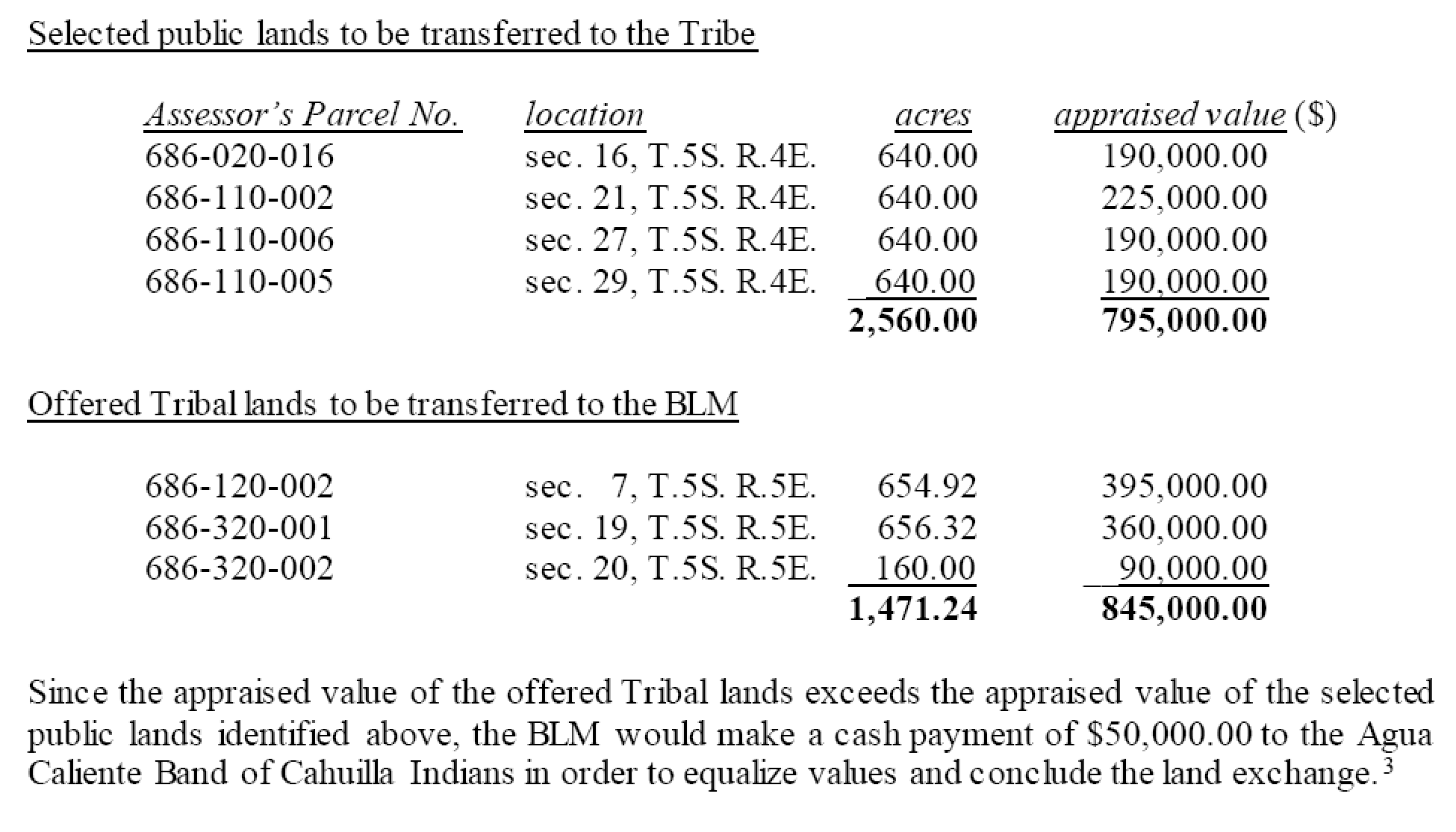
The most controversial parcels that were in the original proposal will not be exchanged, ensuring continued public access to trails and public lands. The original proposal would have given the ACBCI up to 5,799 acres of public land controlled by the BLM, and the public would have received up to 1,470 acres controlled by the tribe.
The chart below summarizes the transaction that has just be approved:
I am still not going to “exonerate” the BLM as a trustworthy steward of public lands. They have a history of turning over our lands to special interest groups and further lining the pockets of the rich at the expense of the public. When the discussions began about the BLM and ACBCI land exchange, a lot was done in secret, and the actions of the BLM were less than transparent. Trying to figure out what the final decision that was published a couple days ago wasn’t easy. I’ll get to that later.
Even our own government knows this. When the Mojave National Preserve was created in 1994 (1.6 million acres), most of the land had been under the management of the BLM, and many in government wanted to remain in the hands of the BLM, but it was given to the National Park Service instead to ensure better management. You can read that story and history in the book, California Desert Miracle: The Fight for Desert Parks and Wilderness.
Bottom Line
So what is the bottom line?
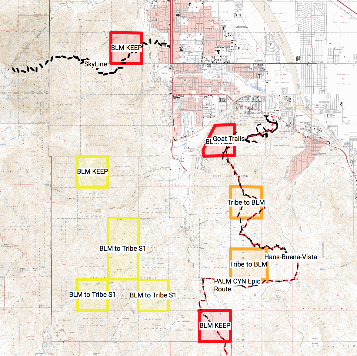
The lands the ACBCI lie within the Santa Rosa and San Jacinto Mountains National Monument. One of the original proposed sections that contained a large portion of the Skyline Trail is not included.
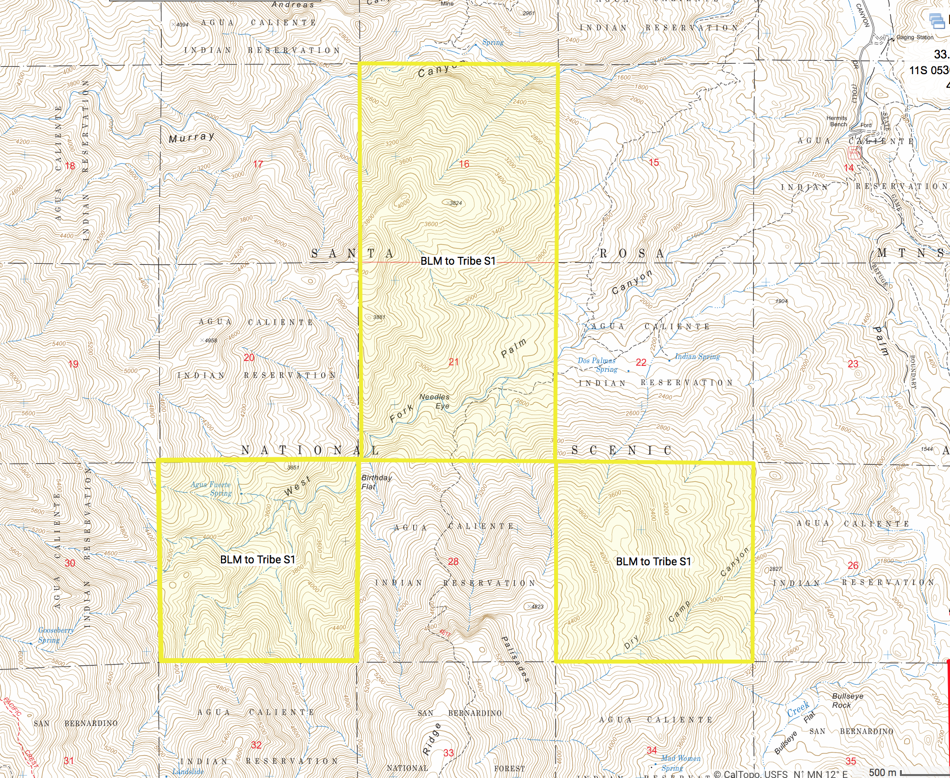
A concern, when it comes to National Monuments or Parks is any Indian lands in the unit really are out of the control of the public and the government. Indian tribes are sovereign nations with sovereign governments, and any deed restrictions or agreements are easily challenged in court and usually favor the tribe. The ACBCI will be receiving 4 sections of land that when added to the existing tribe’s land will create a large contiguous parcel, and the concern is whether they will be able or desire to develop such a large piece of property inside a national monument. If found this CalTopo map on the Internet in which someone has marked the parcels. Here are a couple views I copied:
If we zoom into the four sections the tribe will receive, we can see it is not conducive to development.
There is only one well known trail that passes through the land they will be receiving, the Jo Pond Trail in Section 21, and that trail already is already within ACBCI lands (Section 22 and 28).
Should you be against this land swap, there is a 45 day period to submit a written response. All of the information is on the BLM website and it isn’t easy to find… the email I received wasn’t clear on where the documents were stored and I had to contact the BLM to locate them.
The most important document is the Draft EIS and on the website it had been broken up into 43 separate files, making it difficult to read. So I consolidated all of that into one large file that entails 379 pages (hopefully I got all the files in the correct order). I have uploaded all three documents to PopUpBackpacker if you would like to read them. Warning: the first document is large, at approximately 28MB, and may take a while to load in your browser.
Here are the links:
Draft Environmental Impact Statement (EIS): Draft EIS BLM-ACBCI Land Exchange
The Abbreviated Final EIS: FEIS_Agua_Caliente_Final_508
The Record of Decision: ROD_Agua_Caliente_Land_Exchange_20180118


